Göteborg Weather
 The 17th of January 2016 I will run the Sandsjöbacka 82k race equipped with a GPS tracking device from TracTrac. You will be able to watch my progress through the woods via the web or in your smart phone.
It seems that the weather is going to be a "lovely Swedish winter standard" with freezing temperatures.
The 17th of January 2016 I will run the Sandsjöbacka 82k race equipped with a GPS tracking device from TracTrac. You will be able to watch my progress through the woods via the web or in your smart phone.
It seems that the weather is going to be a "lovely Swedish winter standard" with freezing temperatures.This race is not only a "cold" one, it can be a trail runner’s nightmare!
Let me explain a little bit. Apart the track description provided online by the organizers it's important to understand that:
- Dirt trails are extremely venerable to rut damage during the transition to and from winter because colder temps prevent the soil from drying. When soil freezes the growth of ice crystals push soil particles apart leaving large gaps that can fill with water when the ice melts. In a thawed state this dirt is much like a sponge and will absorb large amounts of water. It is also hyper sensitive to disturbance by foot/bike traffic and flowing water and will form ruts with little effort.
Direct sunlight and above freezing daytime temperatures can thaw the top layer of frozen dirt and create an easily rutted, greasy, muddy mess on the surface. Overnight, lower temperatures refreeze the top surface of the trails, ruts included, and the process repeats when conditions allow (hence the name freeze thaw cycle). [SOURCE]
Running in between all these "gaps" is really difficult and can contribute damaging your feet. Running on icy trails and tricky trail during winter becomes even tougher and you engage additional muscles that you otherwise would not recruit in the same manner on a non-slippery surface. You may fall and hurt yourself if your concentration/preparation is not "good enough". The best way to avoid slipping and falling is to focus on landing with your foot falls directly beneath your hips - Yes, this is quite easy on asphalt, but when running on tecnical frozen trails this still applies but with tons of extra caution and of course proper shoes! You have to be concentrated all the time!
Why running on icy slippery, tough trails? Why am I running/training outside in the cold in Sweden?
This is a "mission impossible" to explain to a non-runner. What I really like with trail running is that I can relax but still engage all my senses and connect with the nature and the surrounding conditions. The key to enjoy the run is I guess the "art" to relax and let the body adapt.... no stress! During the winter conditions everything is on another level. You feel more during the winter silence, you hear the nature and you feel yourself better (I do). Then when the warm days come the results are great! You feel confident with your body, strong and just great! :)
- Choose proper shoes anc clothing. Dress in layers and have an outer windproof layer (preferably breathable fabric) that can be vented. Try to limit your sweating by ventilation.
- Wear a stocking hat and/or balaclava.
- Wear eye protection.
- Wear contrasting and reflective clothing.
- Use a headlamp at night and remember that cars always win, so give them plenty of space and warning! You want to have extra batteries if/when needed!
- Have a full charged cell phone (avoid wifi/bloetooth settings to spare the battery time).
- Hidrate yourself! You want to prevent your bladder from freezing. A few useful tips:
- keep the bladder system inside your jacket or find a insulating tube cover
- reverse the camelbak blivet inside the pouch so the tube it it's entirity is against your back
- filling your bladder with hot water helps
- any high electrolyte beverage will lower the freezing point of water
- Never run alone in the woods!
HAVE FUN!
If you would like to follow me during this adventure feel free to click one of these online services:
- Tractrac
- Eqtiming
or use the Tractrac App:


- Distance 82 km
- Start by Tjolöholm castle
- The race is certified by ITRA to 4 points (new system) and is a qualifying race for all the Ultra-Trail du Mont-Blanc® races 2017 (www.ultratrailmb.com).
- Cut-off times
- Aid station at Lindome (-/40 km) closes at 13:30 (Max time 7 hours)
- Aid station at Kyrkobyn (-/49 km) closes at 15:30 (Max time 9 hours)
- Aid station at Spårhagavägen (11/59 km) closes at 17:30 (Max time 7.5/11 hours)
- Aid station at Sisjön (23/71 km) closes at 19:30 (Max time 9.5/13 hours)
- Finish closes at 22:30 (Maxtid 12.5/16 hours)
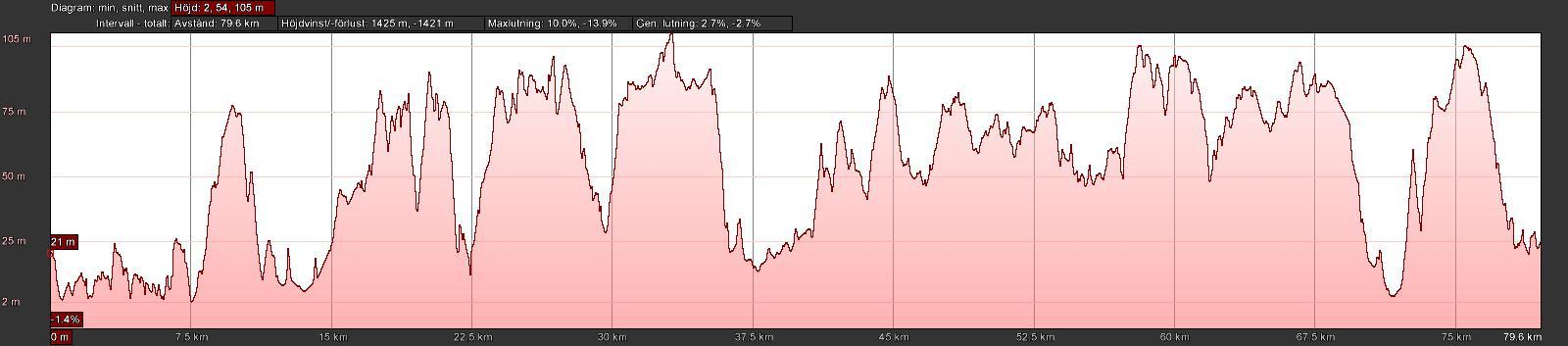
Altitude profile 82 km. Accumulated gain 1420 m.
Course Description
0-6.5 km. Tjolöholm peninsula. Starting at the castle with 2 km easy gravel running out to the shoreline, then technical running in darkness on the walking paths of Tjolöholm with lots of little ups and downs along the ragged coast.
6.5-10.7 km. First part is gravel and easy paths from the harbour to the Äskatorp hills. Second half of the segment is a demanding uphill through the forest and then a meandering path downwards to Äskatorpsvägen.
10.7-15.3 km. Easy running, downhill at gravel road and then asphalt straight on to Fjärås bräcka. Slightly mind numbing segment but helpful to set a meditative mood.
15.3-37.4 km. Hallandsleden/Bohusleden hiking trails from Fjärås to Bunketorp, Lindome. Mainly technical trail with short and sharp ups and downs. Scenic passage at dawn crossing the ancient road across Fjärås bräcka, wiht views out to the sea as well as over lake Lygnern. The rest of the trail is dominated by narrow trails in woodlands except for the crossing of two markedly cultivated valleys, at Hjälm and Hjälmared. The first aid station is by Iglakärr after 25 km.
37.4-42.2 km. Flat and easy, leaving the Hallandsleden hiking trail at Bunketorp, continuing on asphalt on bike paths and countryside road through Lindome, where the second aid station, this one having drop bags and food, is located.
42.4-45.1 km. Dirt road, leaving the fields and entering the woods, some uphill but mostly easy. One very short off-trail passage across a bog and onto a connecting trail in the middle of the segment.
45.1-47.5 km. Scenic running from the tunnel under the highway on hiking trails in open settings across the iconic Sandsjöbacka drumlin. Some uphill but really enjoyable single track running.
47.5-50.7 km. A km on gravel through idyllic Grönabur then back on single track on the red hiking trail – a few wet passages but mostly firm surface and easy running in deep forest along Vildmossedalen. At the end of the segment awaits the third aid station, featuring water and Umara sports drink.
50.7-55.8 km. Blue trail and Sandsjöbackaleden hiking trail from Kyrkobyn to the Grönabur fields. Technical trail in the wilderness of the southwest Sandsjöbacka forest with lots of up and down and running on solid rock as well as in wet and muddy paths.
& 55.8-59.7 km. Easy segment of Sandsjöbackaleden from the Grönabur fields to Mellsjö an onwards on dual track dirt roads and easy single track paths. A slightly more muddy section close to the crossing of Spårhagavägen, where the fourth aid station is located. Segment ends after Kimmersbo with a sharp right onto a forest path.
59.7-63.5 km. Deep forest part of Sandsjöbackaleden and the green hiking trail to Årekärr. This is a technical segment with much up and down and a narrow, winding forest path with roots and rocks.
63.5-66.1 km. Sandsjöbackaleden from the idyllic valley at Årekärr to Oxsjön, still in deep forest, lots of muddy passages here and some uphill, tough running although not extremely technical.
66.1-70.4 km. From the southern shore of Oxsjön, Sandsjöbackaleden ends with wider graveled paths. Some uphill and steep downhill but otherwise easy running. The last aid station is at the end of the hiking trail.
70.4-74.2 km. End of hiking trail. Mixed surfaces, with some paths, some gravel road and some asphalt, first downhill then flat across Fässbergsdalen in western Mölndal. Easy running.
74.2-77.8 km. A few steep climbs with a very short asphalt segment and then a long and really technical passage through the narrow canyon Mölndalsravinen. Ending at the top of Änggårdsbergen with a nice view of Göteborg.
77.8-80.1 km. Downhill with easy running on wide and firm paths through the Botanical garden.
80.1-81.8 km. Asphalt through Slottskogen and then a short trail passage featuring the final twist over the finishing hill and into the stadium.